The following is a guest post by Brad Done, vice president at Reliance Foundry Co Ltd. Done has more than 25 years of experience in manufacturing commercial bike parking and other outdoor metal products.

Wayfinding signs help visitors navigate their route.
As cities around the world compete for tourist dollars, creating user-friendly environments has become a priority for planners. To give visitors the best experience possible, planners have recognized the importance of implementing systems that guide visitors through parks, historic sites and urban centres in a straight-forward manner. These systems make up a process known as “wayfinding” and they are an effective way for cities to promote their brand.
In simple terms, wayfinding refers to the systems that are employed to help tourists and visitors orient their position and get to their desired location. When properly implemented, the systems should help the tourists determine where they are, designate the route they should take, reassure them that they are following the correct route once they have committed and finally they should confirm arrival at the desired destination once it has been reached. When correctly structured, wayfinding infrastructure will help visitors navigate the course to their desired location while setting their minds at ease.
Select your wayfinding system. Signage, large maps and even touch-screens can be used to help people orient where they are in relation to where they wish to travel. These wayfinding systems should provide a graphic representation that clearly identies where the visitors are positioned. They should also provide operational and regulatory information, such as the site’s hours of operation and any safety precautions that may be necessary. Finally, these wayfinding systems should help visitors visualize their path and make a route decision.
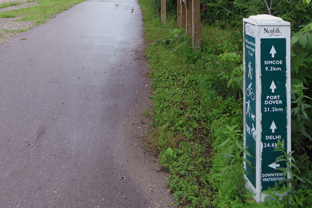
Wayfinding bollards “monitor” visitors as they travel.
After a visitor has selected a route, their mind should be set at ease by systems that reassure them that they are on the correct course. This segment of wayfinding is known as route monitoring.
Designate the route. Pathways, fencing, and bollards can all be used to designate a route that establishes a clear beginning, middle and end for the user. They should be connected and uniformity is often achieved with a series of visual cues. The city’s logo or an icon that clearly represents the history of the site regularly serve this purpose. For example, In Nashville, guitar pick signs direct visitors between historic music sites.
Use lighting effectively. The devices used to map out a route can do more, however, than promote a city’s brand. Often, they also serve a very pragmatic function. If a site welcomes visitors in the early morning or at night, darkness presents a serious obstacle to wayfinding and lights become a necessity. In these applications, wayfinding marker must either light or be lit. That is to say, that lights can be used as wayfinding devices that illuminate the necessary path or they can be incorporated into the existing wayfinding markers as is the case with solar lighting bollards.
Consider safety and multiuse paths. While en route, the visitors’ safety should be taken into consideration. Obviously, foot traffic should be separated from vehicular traffic but in certain situations, walkers may need to share pathways with cyclists, joggers and roller skaters. To prevent accidents in these applications, lane ways should be clearly marked on the ground and flexible bollards can be used to prevent cyclists from veering into foot-traffic lanes at high density points.
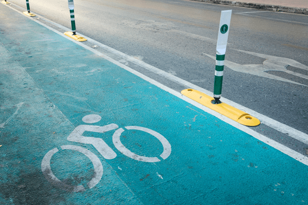
Flexible bollards
Provide destination cues. Once the visitor safely arrives at the site, an effective wayfinding system will provide destination recognition. To guarantee that a site will be successfully recognized, it should be set apart from its surroundings. This can be achieved with barriers that enclose the area, interrupt the pedestrian movement and create dead-ends. Depending one the aesthetics of a site, these barriers may take the form of walls, concrete blocks, fencing, bollards with chain or even shrubbery.
Incorporate city branding. Planners will also often incorporate a city’s brand into the wayfinding systems used in destination recognition. Systems that aid in destination recognition range from the basic, which could be as simple as a sign that announces the name of the site or as elaborate as the bear-head bollards that line the perimeter of the state capitol facilities in Sacramento, California.
The Wayfinding efforts of city planners have brought a new level of convenience to tourism by creating step-by-step guides to parks, historic sites and other “must-see” locations. Not only have their wayfinding systems improved user experience, they have also allowed cities to brand themselves and promote their unique cultural landmarks. With innovations in smart phone technology, expect the implementation of wayfinding systems to grow considerably in the near future.
Wayfinding Resources for Cities
- Nick Addamo, “The 10 Latest Trends in Master Planning,” Architizer, October 29, 2014.
- William Lidell, Kristina Holden and Jill Butler, Universal Principles of Design: 125 Ways to Enhance Usability, Influence Perception, Increase Appeal, Make Better Design Decisions (Miami: Rockport Publishers, 2010).
- Bill Main and Gail Greet Hannah, Site Furnishings: A Complete Guide to the Planning, Selection and Use of Landscape Furniture and Amenities (Toronto, Wiley, 2009)
- “What is Wayfinding,” The Society for Experiential Graphic Design, accessed May 24, 2017.
- “What is Wayfinding,” University of Michigan, accessed May 24, 2017.